Posted in
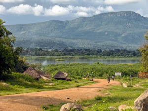
Adjumani was curved from Moyo District in 1997. It is composed of East Moyo county which together with West Moyo County previously made up Moyo District. At Independence in 1962, it was known as Madi district. Adjumani and Moyo Districts are separated by the Albert Nile.
Location
Adjumani District is bordered by the Republic of Sudan to the North, Gulu to the east and south and Arua, Moyo and Yumbe District in the west.
Population
The district has over 201,493 people. 99,991 are Males and 101,502 are Females.
Main Languages; Madi, Lugbara and Acholi.
ECONOMIC ACTIVITIES
Agriculture with main emphasis on food crops such as millet, potatoes, beans, and cassava. Cash crops include cotton and coffee. There is fishing on the River Nile.
Banks; Stanbic Bank Ltd.
Health services
The district has 1 Government dispensary (II), 6 health centres (III) at county, no health centre (IV) at sub-district and 1 hospital. More so, it has 22 private/NGO dispensaries, 24 clinics, 2 health centres (III) and 1 hospital- Pakele Mission Hospital. There is also a Government District hospital-Adjumani Hospital with 100o beds.
Education Services
The district has a total of 80 primary schools with 58 government, 6 private and 16 community schools. For secondary schools, the district has over 15 schools, 2 are government, 4 private and 9 community.
Transport Network
The district has a murram road network linking some parts of the district. There is a ferry service linking Adjumani and Moyo districts across the River Nile. The district has an airstrip where scheduled and chartered flights are available.
Tourist Attractions
Its rather flat landscape adds to the beauty of the place blending in with the distant horizon. At night the deep, blackness of the landscape with bright stars above is lovely.
Photo Credit: Clare Wise de Wet