Posted in
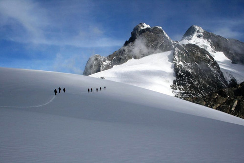
If you like hiking, then the (5,119 m) high, snow capped Rwenzori Mountains – also known as the ‘Mountains of the moon’– will offer you the unique experience you’ve been looking for. The Rwenzori is the highest mountain range in Africa. It lies along Uganda’s western border with the DRC, they are sometimes referred to as the ‘Mountains Of The Moon’. Rwenzori Mountains National Park was proclaimed a World Heritage Site to protect the natural beauty, flora and fauna of the area. The Rwenzori are a true mountain range created by up lift of the earth crust through tectonic movement and are not as a result of volcanic activity. The range is 120 km in length and 48 km in width. The mountains are frequently shrouded in mist and cloud with the peaks rarely being visible from far.
At the center of the range, there are six peaks carrying permanent snow, three with glaciers. The highest of these peaks, and the third highest peak in Africa, is Mt. Margherita rising 5102 meter above sea level.
The Rwenzori Mountains were gazetted as a National Park in 1991. The Park covers 996 square km of rugged mountain terrain offering visitors a rare experience of an Afro-Montane rainforest. These forest start above 3000 m and includes the giant forms of Lobelia, Heather and Groundsel.
The Rwenzori Mountain Hiking provides exhilarating rewarding experience but one, which must be Well planned. The key to an enjoyable Uganda tours must be prepared! The central circuit hike takes six nights/seven days and reaches an altitude of 14,000ft (4,267m) above sea level.
The conditions on the mountain are a challenge to even an experienced hiker because this mountain is known for its un-engineered, steep and slippery trails, frequent rainfall, cold temperatures, bogs, mud, steep terrain and high altitude.
However you can try it, it’s an exciting experience and since the periods of July-August, December-February are relatively dry for inexperienced hikers.
During any season, rain gear, good sleeping bag, warm hat, gloves, heavy socks, gum boots, gaiters and a walking stick for balance are recommended plus a basic first aid kit.
Porters will be carrying your heavy equipment and food, leaving you with a small pack, rain gear, warm clothes, camera water and any other light luggage.
You can purchase your own food and Rwenzori mountaineering service can provide cooking utensils and cooks.
THE CENTRAL CIRCUIT TRAIL
DAY ONE: (NYAKALENGIJA-1,615m TO NYABITABA HUT-2,651m)
This trailhead is at Nyakalengija, 22Km from Kasese off the Fortportal Road. The RMS can arrange transport from Kasese to its main office at Nyalalengija, where you will pay park fees and finalize arrangements. There is a campsite and safe parking near the office. From Nyagalengija, it’s a 10Km, five-hour ascent to the Nyabitaba Hut, passing first through cultivation than through forest. There is a piped water supply at the hut.
DAY TWO: NYABITABA HUT TO JOHN MATE HUT (3,505m)
This is the longest and most strenuous day’s walk; expect it to take a minimum of seven hours. From Nyabitaba Hut, the path descends through forest for a short time before it crosses the Bujuku River at the Kurt Scehafer Bridge (built in 1989). Between the bridge and Nyamileju Hut, the path is good for the first couple of hours, but it becomes steeper and very rocky as you enter the moorland zone, where heather plants are prolific.
You will probably want to stop for lunch at Nyamileju, where there is little-used and rather rundown hut, as well as a rock shelter. After leaving Nyamileju, the path passes a giant heather forest and follows the Bujuka River. John Matte hut is about a two-hour walk from Nyamileju. The hut is about a two-hour walk from Nyamileju. The hut is about 200m from Bujuku or Kitandara huts.
DAY THREE: JOHN MATTE HUT TO BUJUKU HUT (3,962m)
This takes up to 5 hours, depending on the condition of the two Bigo Bogs, which are often knee-deep in mud. On the way to the hut you will pass Lake Bujuka, which is a magnificent setting between mounts Stanly, Speke and Baker. There is water 20m from Bujuku hut.
Bujuka hut is the base for reaching Mount Speke and you will need to spend an extra night there in order to do this. If you want to climb to the highest point in the range, Margherita Peak on Mount Stanley (5,109m), you must do this from Elena Hut(4,541m), which is about 2km off the Loop Trail and 3 hours walk from either Bujuku or Kitandara.
DAY FOUR: BUJUKU HUT TO KITANDARA HUT (4,023m)
From Bujuku hut you will ascend to the highest point on the Loop Trail, Scott Elliot Pass (4,372m) before descending to the two Kitandara lakes. The hut is next to the second lake.
DAY FIVE: KITANDARA HUT TO GUY YEOMAN HUT (3,505M)
This is a five hour walk, starting with a steep ascent to fresh field Pass (4,282m) then a descent to Bujongolo cave (3,720m), the base used by the 1906 expedition. Further along the trail at kabamba cave (3,450m) there is so attractive waterfall and rock shelter where you can stay overnight as an alternative to Guy yeoman Hut.
DAY SIX/SEVEN: GUY YEOMAN HUT TO NYAKALENGIJA
It is a 5 hour descent from Guy Yeoman Hut to Nyabitaba Hut. You can either stay overnight at the hut or else continue at Nyakalengija which will take 3 hours.
![]()
SIZE:
998 sq km
LOCATION:
Located on the Congo border close to Kasese.
ACCESS:
By Road: From Kampala via Mbarara to Kasese, then continue 18km to Ibanda. Also from Kampala through Fort Portal and then 75km on the Fort Portal/Kasese road south. The Park is 25 km from Kasese. Take a left turn 4 km after leaving Kasese on the Kasese-Fort Portal road.
Air: From Kampala to Kasese and then by road.
WHEN TO VISIT:
During dry seasons that is December-February and June-August.
WHERE TO STAY:
Hostel and campsite at the trailhead, essential hiking huts along the loop trail. Nearby Kasese has a midrange hotel, several budget a campsite and lodgings